How to make a Fantasy Map
怎样制作一张幻想世界的地图
作者:JANLOOS 发布时间:2019/01/23
翻译:AzirKxs
原文链接:How to make a fantasy map (online-tabletop.com)
In this guide, we make a map for your fantasy world. Even though we are making a fantasy map, we will create an earth like world.
这是一篇帮助你制作属于你自己的幻想世界地图的向导。尽管我们已经制作了一张幻想的地图,但我们还将创造一类似于地球的世界(生态)。
To add believablility to our map, we will figure out why the continents are shaped the way they are, how climate works, and how we can place realistic details such as mountain ranges, volcanoes, and rivers in the right places.
为了增加我们地图的可信性(真实性),我们要弄明白他们的大陆是什么形状的,他们有怎样的气候,以及要知道一些真实的细节要出现在正确的位置上,例如山脉,火山还有河流。
1 | figure out:想出,解决,弄清 |
The earth and its layers
地球和它的层次
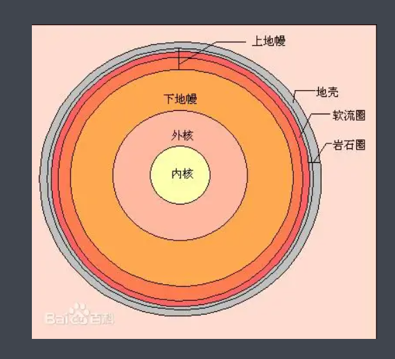
The earth’s crust lies upon it’s mantle of hot stone. Underneath the mantle is an outer core of liquid metal. The inner core is a solid ball of metal. Even though the inner core is very hot, the pressure keeps it from melting.
The crust of our earth is like a cracked egg shell. The cracked parts of the earth are called tectonic plates. These slowly move around on top of the earth’s mantle.
Over the course of millions of years, continents have been colliding and dividing. About 250 million years ago, two great continents collided, creating the supercontinent called Pangea.
After about 50 million years, Pangea started to break apart. It slowly created the continents we have today.
If you look at our worlds map, you can see that some continents such as South America and Africa, seem to fit together like a jigsaw puzzle.
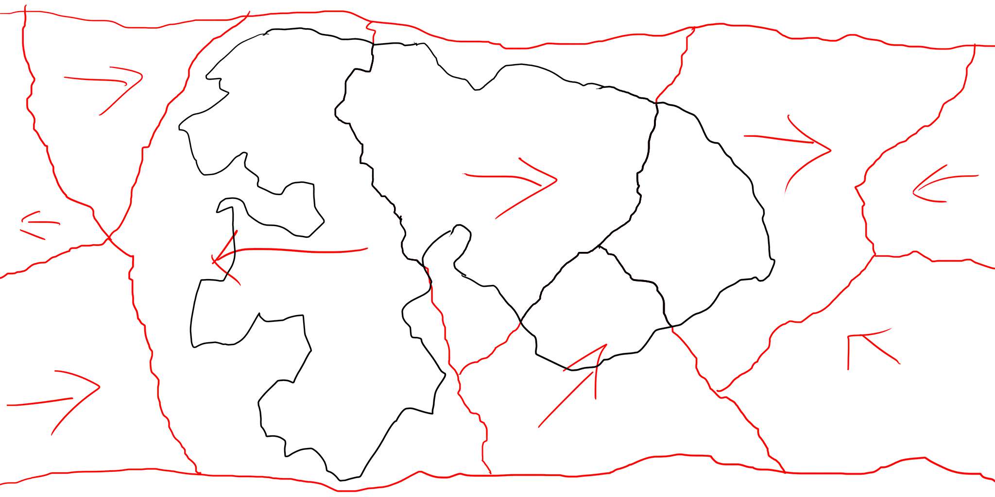
Start drawing a supercontinent on your custom map. Make sure the landmass covers about one third to a quarter of the fantasy map.
Sketch in five to ten large tectonic plates and decide which way the plates are moving.
地球的地壳依靠覆盖在热地幔之上,在地幔下是一个液态金属外壳,其内部核心是一个实心金属球。即使这个内部核心是非常热的,但在压力的作用下它没有融化
地球的地壳像是一个撞碎了的鸡蛋外壳,破裂的的地方被称为了构造板块,它们缓慢的移动在地幔的上方。
在数百万年间,大陆一直在碰撞和分裂,大约250万万年(两亿五千万年)之前,两个巨大的大陆相撞,创造了名为Pangea(泛古陆)的超大陆。
在之后大约在五千万年,Pangea开始分裂。他缓慢的创建了我们今天的大陆。
如果你看我们的世界地图,你会看到一些大陆像是拼图玩具,例如南美洲和非洲。
开始绘制一块超大陆在你自己的地图上。确保他的面积覆盖了你幻想地图的三分之一到四分之一。
将他画成五到十个大陆板块并且决定他们向哪一个方向移动。
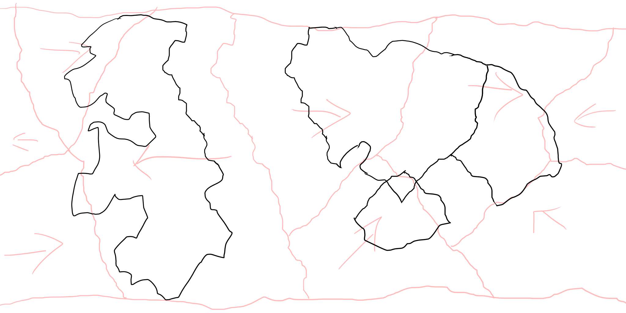
Next, start splitting your supercontinent up. This is easily done in design program.
If you are using pen and paper, grab a piece of paper in another color. Roughly cut your piece of paper up in the shape of your continents, and move them according to your tectonic plate.
接下来,开始将你的超大陆分开,这是简单的在一些设计软件上。
如果你使用的是铅笔和纸,抓来另一张纸使用另一种颜色。粗略的剪下来你大陆的形状并且移动他们根据你的构造板块!
经本人调查,转自百度百科,第一段是指软流圈。
1 | crust:地壳 |
Mountain-ranges
山脉
When two of the tectonic plates collide, one slides underneath the other one, pushing the other one upwards. This creates mountains.
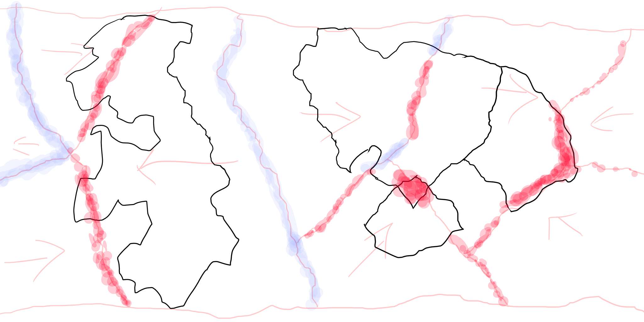
Lets continue working on our fantasy map. The area’s where tectonic plates collide will have mountain ranges. Lets take a different color, like red, and roughly sketch in where the collisions take place.
Take another color, such as blue, and start roughly sketching in where tectonic plates would divert from each other.
当两块板块相撞,一个板块滑动到了另一个板块下,向上推动就形成了山脉。
让我们继续绘制你的幻想地图。这里的板块相撞将会形成山脉。让我们换一种颜色,例如红色,粗略的绘制在他们相撞的地方。
在取另一种颜色,例如蓝色,粗略的绘制在板块将相互偏移的位置
1 | undereath:在……下面 |
Volcanoes
火山
When two plates collide, magma from the earth’s mantle can find a way up through the cracks in the plate edges. The magma pushes outwards with great force, causing an eruption.
When the plates continue to move, magma can find its way through the old weak spots where a volcano was previously active. The volcano will erupt once more, and the lava will add another coat of rock on top, causing the volcano to grow in size.
Volcanic islands come to exists, when magma flows upwards when two tectonic plates move away from each other. The magma is cooled down by the water of the oceans, creating a layer of volcanic rock. This continues to happen layer upon layer, until a volcanic island pops up above the surface of the ocean.
Not all volcanoes come to exist at the edge of a tectonic plate.
The Islands of Hawaii for example, are a group of islands formed in the middle of the oceanic plate. These type of islands are very rare, and happen around places called hotspots.
Scientists are not completely sure how hotspots come to exist. One theory suggests it happens when magma travels through the earth’s mantle, forming a blob of magma under the earth’s crust.
Over the course of millions of years, the volcano moves together with the tectonic plate. The hotspot however stays roughly in the same location. This creates new volcanic islands, making an island chain.
When drawing tectonic plates on your map, add some volcanic island chains around the edges. Also add three or four island chains created by tectonic hotspots.
当两个板块相撞,地幔下面的岩浆会沿着板块边缘的裂缝向上溢出。岩浆伴随着巨大的力量向外冲出,造成了喷发。
当板块继续移动,岩浆会发现先前发生过喷发的(活动的)火山留下的旧裂口。于是,火山将再次喷发,并且火山岩的上面将增加另一层的岩石造成火山规模的增大。
当岩浆沿着从两个彼此远离的板块之间之间向上流出时,就形成了火山岛。岩浆经过海洋中的水冷却后就形成了一层火山岩。一层接着一层不断持续知道一个火山岛覆盖在了海洋的表面.
不是所有火山都出现在板块的边缘。
像夏威夷这样的岛屿,它是形成在大洋板块中间的一组岛屿。这种类型的岛屿是非常少见的,发生在所谓的热点周围。
科学家们不能完全确定了热点是怎样形成的。一种推测是岩浆穿过地幔,在地壳的下面形成了一团岩浆,就造成了这种情况。
经过几百万年,火山随着板块一起移动。然而热点大概还停留在原来相同的位置,这就创造了新的一些岛屿岛屿,最终形成了链状的岛屿。
当我们绘制板块在你的地图上时,在它们的边缘上增加一些岛屿。同时也增加三到四个通过板块热点形成的岛屿。
1 | megma:岩浆 |
Coastal Erosion
海岸线侵蚀
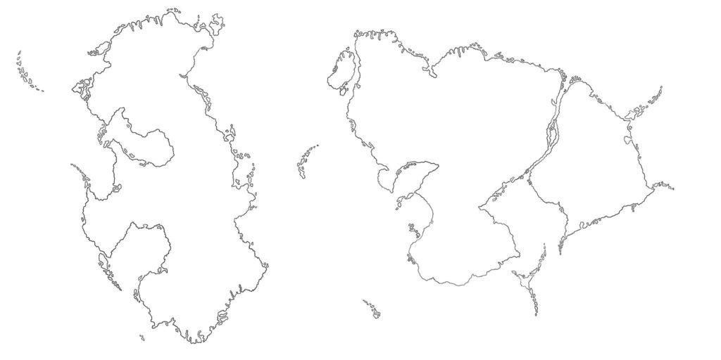
Now that we know the location and shape for our continents, and we know where our mountains and islands chains will be. It is time to add some details.
The force of the water changes the way the coasts of continents look. This is called coastal erosion.
The constant force of the water, slowly chips away at the coasts. The sediments are moved by the sea and may wash up somewhere else.
For now it is enough to know that our coastlines are not perfectly straight. The continents continents may look like puzzle pieces that can fit together, but erosion jagged up the edges.
Trace the continents you have drawn in, but now roughen up the coast lines a little to simulate erosion.
现在我们知道了大陆的位置和形状,并且我们也知道了山和岛屿的位置。是时候增加一些细节了。
在水力作用下改变了大陆海岸线的样貌。它被称为海岸线侵蚀(这就是所谓的海岸侵蚀)。
在水力的不断作用下,渐渐地使海岸线被剥离。这些沉积物通过海水移动并且肯能被冲到别的地方。
现在可以充分的证明我们的海岸线不是完美的直线。大陆可能看起来像是拼图可以将他们拼在一起,但是侵蚀使得边缘层次不齐。
找到你已经绘制好的大陆,现在粗略的模拟一点海岸线的侵蚀。
1 | chip: 薯片,缺口,碎片;打破,切下,剥下 |
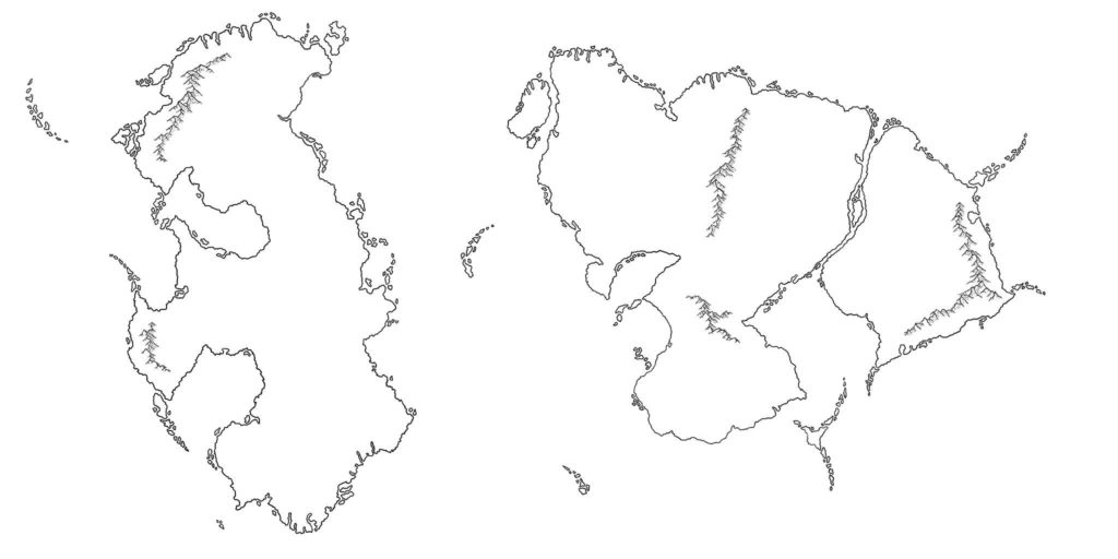
We already roughly sketched in where our mountains will be. Now it is time to add them. A separate tutorial on drawing mountains will be added later.
For now I can recommend Questing Beasts youtube tutorial on how to draw mountains for cartographers.
我们已经粗略地绘制山脉在地图上。现在是时候增加它们了。之后将单独增加绘制山脉的教程。
现在我可以向制图员推荐 Questing Beasts youtube tutorial如何绘制山脉的视频。
1 | separate:分开,分割,分离;单独的,独立的 |
The Climate System – Sunlight
气候系统-阳光
The most important factor in our climate system is the sun.
In the movie Star Wars, you can see Luke Skywalker standing on his planet Tatooine, watching two suns set.
With the discovery of the planet Kepler-16b, scientists have confirmed that there are planets orbiting two stars. So Tatooine like worlds may be possible.
Two suns would complicate the climate system of our fantasy world by quite a bit. That is why we will stick with one sun for this guide.
We all know that our earth spins around an axis with the north pole at the top, and the south pole at the bottom. And we also know that the earth revolves around the sun.
The angle at which the earth revolves around its axis, and the angle at which the earth revolves around the sun are different from each other.
While the earth revolves around the sun, different parts of the earth catch more sunlight… This causes the seasons of the year.
The places around the equator, receive large amounts of sunlight all year round. Causing them to be the warmer places on earth.
A little bit further from the equator, we find the tropical zones. They get more or less sunlight depending of the time of the year. So they are more affected by the seasons. However, since they are so close to the equator, they still catch a lot of sunlight, making them warm places on earth.
Next to the tropical zones, we have the temperate zones. These are much more affected by the seasons. They can go from, very warm in the summer, to very cold in the winter.
Next to the temperate zones, we have the top and the bottom of our axis, the polar regions or also known as the arctic and antarctic circle. These receive the least amount of sunlight, causing it to be cold all year around.
影响气候最主要的因素是阳光。
在电影星球大战中,你可以看到卢克·天行者站在他的星球塔图因上看两个太阳落山。
随着开普勒-16b行星的发现,科学家们确定了这儿有一颗行星围绕着两颗恒星。因此像塔图因这种世界是可能存在的。
两个太阳将使得我们的幻想世界气候系统变得稍微有点复杂。这就是本篇向导坚持使用一个太阳的原因。
我们都知道地球以在地球顶部的北极和地球底部的南极为轴旋转。并且我们也知道地球绕着太阳旋转。
地球绕其轴线旋转的角度和地球绕太阳旋转的角度时彼此不相同的。
随着地球围绕太阳的旋转,地球不同部分会捕捉到更多的光照。这就造成了一年中的季节。
在赤道周围的地方,全年将吸收大量的阳光。使他们成为了地球上更热的地方。
离赤道远一点的地方,我们可以发现热带。 根据一年中时间的不同它们可以得到更多的或者更少的阳光。因此它们更受季节变化的影响。然而,因为它们接近赤道,他们仍然吸收了大量的阳光,使得他们成为了地球上温暖的地方。
与热带相邻,我们还有温带。这里受季节的影响较大,夏天非常炎热,冬天非常寒冷。
与温带相邻的是轴的顶部和底部,也就是极低区域,也被称为北极圈和南极圈。它们接受最少的光照,造成了它们全年都很寒冷。
1 | orbiting:环绕,沿着轨道运行 |
开普勒-16b是由美国宇航局开普勒探测器观测到一颗巨大行星环绕一对恒星,这一颗环绕两颗恒星运行的行星,这意味着它将像塔图因行星一样,天空中出现两颗太阳。
The Climate System – Weather Cells
气候系统-气象单元(环流圈)
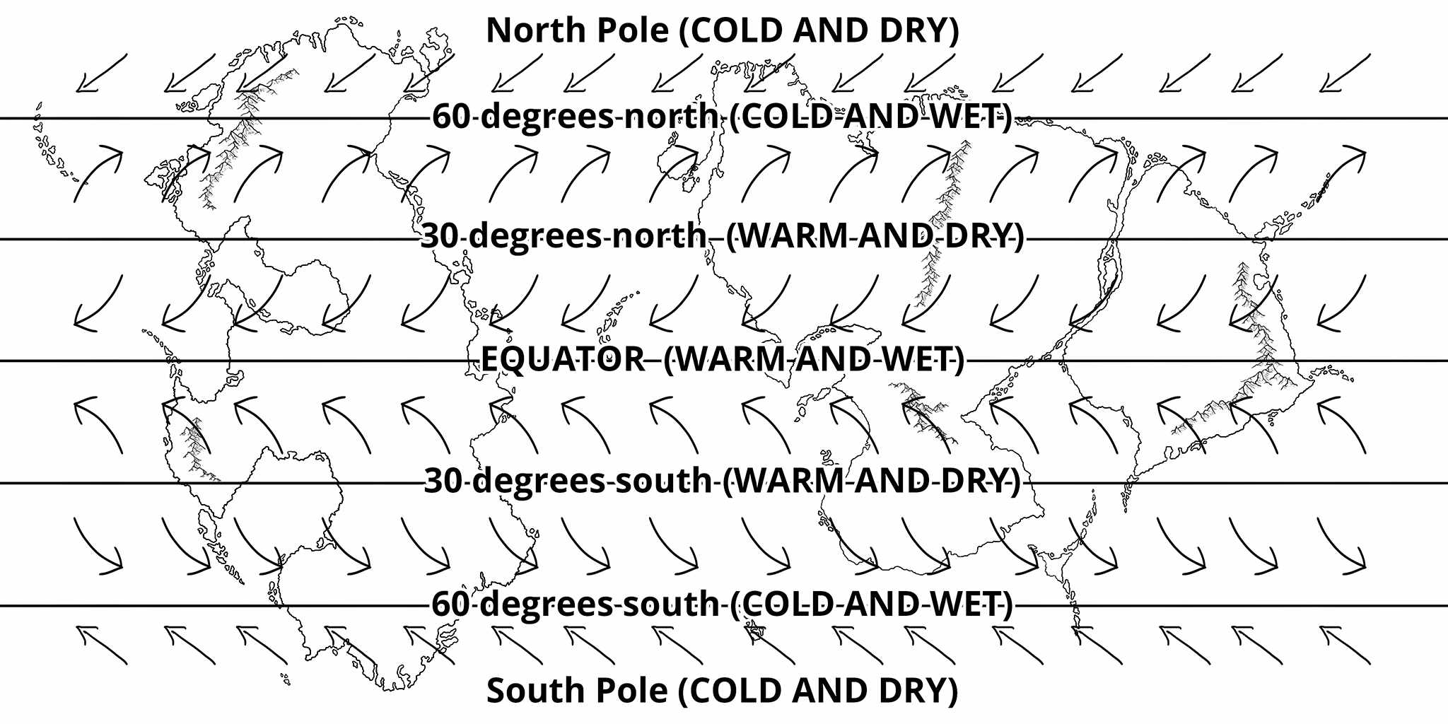
Wind also plays a big role our climate system. The weather system however is very complicated.
For now it is enough to know that there are six donut shaped weather cells that surround our globe. If you want to know more details, I suggest that you do some searching on the names of the different weather cells. The cells are called Hadley Cells, Ferrel Cells, and Polar Cells.
Around the equator, the weather is warm and wet. A perfect area for rain forests.
30 degrees north and south of the equator, the weather is warm and dry. A perfect area for deserts.
60 degrees north and south of the equator, the weather is colder and wet.
At the north and south pole, the weather is cold and dry. If Antarctica would not be covered by ice, it would be as dry as the Sahara.
The wind in these weather cells follow a certain pattern. This can cause certain coastlines to be warmer or colder than they should be according to their latitude.
Start imagining what area’s of your fantasy world map would have what type of climate.
气流也扮演一个大的角色在我们的气候系统中。然而,天气系统是非常复杂的。
现在我们知道地球的周围有六个甜甜圈形状的气象单元就足够了。如果你想知道更多的细节,我建议你去搜索不同气象单元的名称,它们就是所谓的哈德利环流圈,费雷尔环流圈和极地环流圈。
在赤道附近,气候是温暖和潮湿的。一个完美的雨林区域。
赤道以北和以南30度,气候是温暖的和干燥的。一个完美的沙漠区域。
赤道以北和以南60度,气候是寒冷的和潮湿的。
在北极和南极,气候是寒冷的和干燥的。如果南极洲不被冰覆盖,他将变得和撒哈拉一样干燥。
在这些气流单元中气流遵循某一种形式。这可以造成某些海岸线比他们所在的维度变得更温暖或者更寒冷。
开始想象你的幻想世界地图中的哪个区域会有哪种气候。
1 | cell:细胞,小房间,牢房 |
Fjords
峡湾
During the ice age, glacial ice covered much of the land near the poles.
Over thousands of years, the glacial ice moved back and forward over the lands. Melting and freezing over again.
Area’s with high altitude near the coasts, close to the poles, were affected by this glacial ice a lot. Creating sharp and steep narrow inlets.
On our earth, we find many fjords in Alaska, Greenland, and Norway on the northern hemisphere. But also in New Zealand, Southern Chili, and Antarctica on the southern hemisphere.
When you are drawing your custom map, add some fjords to make your map more believable.
在冰河时代,冰川覆盖了两极附近的大部分陆地。
几千年后,冰川在大陆上来回移动。不断地融化和冻结。
海岸线附近接近极地的高海拔地区,受到了大量冰川的影响。创造了锋利的和陡峭的狭窄入口。
在我们的地球上,我们发现了许多峡湾,在北半球的阿拉斯加,戈兰林和挪威,同样也有在南半球的新西兰,南智利和南极洲。
当你在绘制你的自定义地图时,增加一些峡湾去确保你地图的可信性。
1 | glacial:冰河的,冰川的 |
如果这篇文章对你有帮助,可以bilibili关注一波 ~ !此外,如果你觉得本人的文章侵犯了你的著作权,请联系我删除~谢谢!